一张图片,就足以构建一整个电影般的世界。
分享链接 · https://openimages.ajiang.me/p/2094618926475055509/
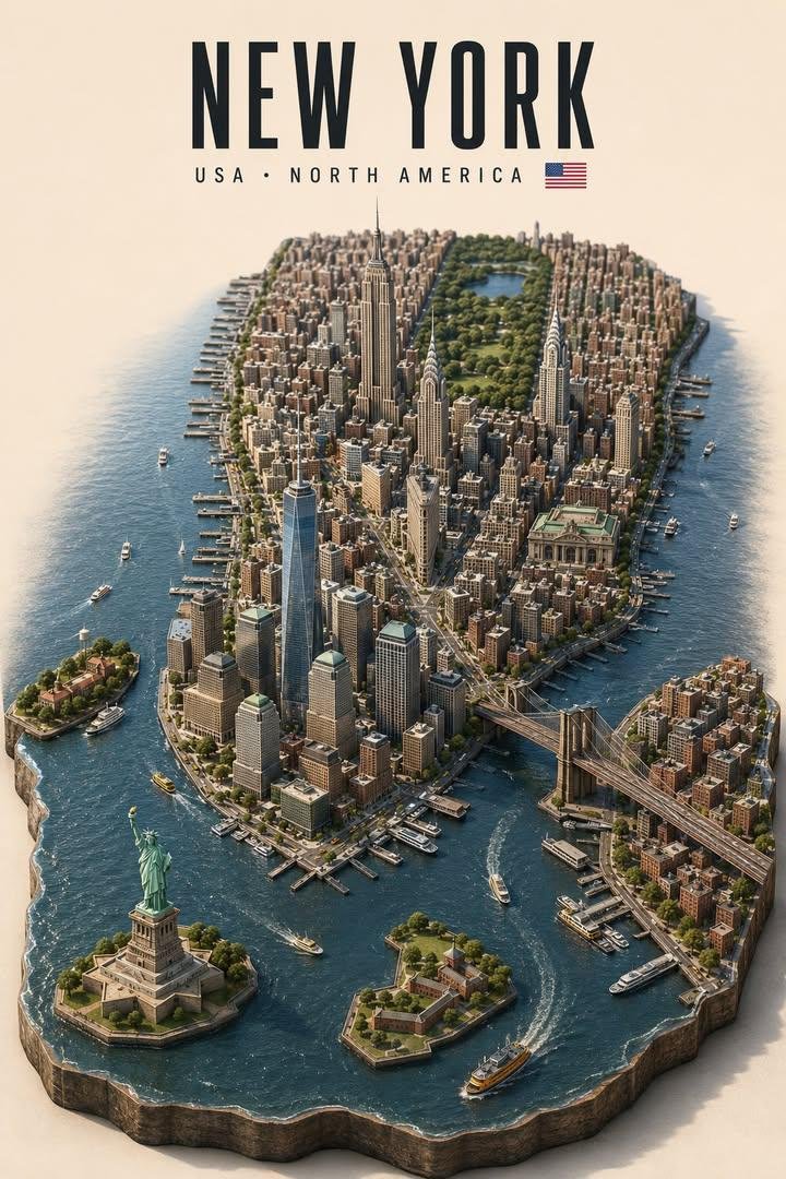
camera_lens · orthographiccomposition · centeredcomposition · high-anglelighting · soft-lightmood · elegantquality_flags · embedded-text
提示词(原文,逐字保留)
One image was all it took to build an entire cinematic world.
Created with GPT-2, then brought to life with Seedance 2.5
PTOMPT 👇
DESTINATION CORE-IDENTITY 3D ISOMETRIC DIORAMA — META PROMPT
DESTINATION = [DESTINATION]
SCOPE OVERRIDE = AUTO
Create a premium vertical 3D isometric miniature diorama of [DESTINATION], focused on its most internationally recognizable geographic and cultural core.
Silently identify the country, region, visual identity, essential geography, and 5–8 iconic elements before composing.
━━━━━━━━━━━━━━━━━━
1. GEOGRAPHIC SCOPE
━━━━━━━━━━━━━━━━━━
Use the smallest coherent area that best represents [DESTINATION], not automatically its full administrative boundary.
Prioritize:
1. recognizable island, peninsula, river corridor, harbor, historic center, urban district, or mountain basin
2. landmark-dense central area
3. full territory only when its entire outline is compact, distinctive, and essential to its identity
For large metropolitan areas, exclude generic suburbs, airports, industrial districts, satellite towns, and low-information outskirts unless they contain an essential landmark.
Maintain:
ICONIC CORE 75% + SUPPORTING CONTEXT 25%
If SCOPE OVERRIDE is provided, treat it as authoritative.
━━━━━━━━━━━━━━━━━━
2. TERRAIN FOOTPRINT
━━━━━━━━━━━━━━━━━━
Use the recognizable silhouette of the selected iconic core as the elevated terrain base.
The complete terrain must remain visible, centered, and uncropped. Preserve important coastlines, rivers, islands, harbors, mountains, waterfronts, and directional relationships.
Geography may be compressed for clarity, but never reversed or randomly rearranged. Preserve relative positions such as opposite riverbanks, island and mainland, city and mountain, landmark and waterfront.
This is a refined geographic travel artwork, not a literal GIS map.
━━━━━━━━━━━━━━━━━━
3. LANDMARK HIERARCHY
━━━━━━━━━━━━━━━━━━
Select 5–8 authentic elements:
– 1–2 PRIMARY HERO LANDMARKS
– 3–5 SECONDARY LANDMARKS
– 1 natural or geographic feature where appropriate
Choose them by recognizability, cultural importance, distinctive silhouette, and relevance to the selected core.
Hero landmarks must be the largest, clearest, and most visually dominant. Secondary landmarks must remain smaller and supportive.
Preserve each landmark’s defining silhouette, proportions, roofline, structure, materials, and characteristic colors. Slight enlargement is allowed for legibility, but avoid excessive scale distortion.
Use each landmark only once.
━━━━━━━━━━━━━━━━━━
4. GEOGRAPHIC INTEGRATION
━━━━━━━━━━━━━━━━━━
Place landmarks in approximately correct relative locations. Keep real clusters together and preserve meaningful relationships:
– bridges connect the correct shores
– waterfront landmarks remain beside water
– skyline towers remain within their real cluster
– historic landmarks connect to their neighborhoods
– mountain landmarks remain on elevated terrain
Connect everything through appropriate streets, bridges, parks, plazas, neighborhoods, vegetation, waterways, coastlines, hills, and terrain.
The result must feel like one continuous miniature world, not separate souvenir objects.
━━━━━━━━━━━━━━━━━━
5. CINEMATIC COMPOSITION
━━━━━━━━━━━━━━━━━━
Design the image as a camera-ready establishing frame for future image-to-video animation.
Create three clear depth layers:
FOREGROUND — water, shoreline, road, park, plaza, or terrain edge
MIDGROUND — Hero Landmark and primary city district
BACKGROUND — secondary skyline, historic district, mountain, harbor, or natural boundary
Use one continuous river, avenue, bridge route, coastline, harbor, valley, or urban axis to guide the eye from the foreground toward the Hero Landmark.
Keep important silhouettes separated. Avoid excessive overlap, fragile thin structures, uniform density, and unnecessary micro-buildings that may flicker or deform during animation.
━━━━━━━━━━━━━━━━━━
6. STYLE AND FORMAT
━━━━━━━━━━━━━━━━━━
Render as a sophisticated high-detail 3D architectural miniature with:
– high-angle three-quarter isometric view
– orthographic-like perspective
– sculpted terrain elevation
– realistic miniature architecture
– refined model-making craftsmanship
– polished but restrained materials
– realistic glass, stone, metal, water, foliage, and roof textures
– detailed ambient occlusion
– soft contact shadows
– premium museum-display quality
Format:
– vertical 2:3 or 3:4
– diorama occupying the lower 68–75%
– complete terrain footprint visible
– generous upper negative space
– warm off-white studio background
– subtle shadow beneath the terrain
– no decorative border
The style must feel elegant, realistic, and architectural—not cartoonish, chibi, toy-like, low-poly, or flat.
━━━━━━━━━━━━━━━━━━
7. EDITORIAL HEADER
━━━━━━━━━━━━━━━━━━
At the upper center, display exactly:
[DESTINATION]
[COUNTRY · REGION OR CONTINENT]
[ACCURATE NATIONAL FLAG]
Use a bold condensed uppercase sans-serif title with a smaller, widely tracked uppercase supporting line and one small accurate flag.
No slogans, captions, dates, coordinates, street names, landmark labels, or additional text.
━━━━━━━━━━━━━━━━━━
8. FINAL CONSTRAINTS
━━━━━━━━━━━━━━━━━━
The destination must be recognizable before reading the title.
Ensure:
– iconic core dominates
– Hero Landmark is immediately clear
– geography remains plausible
– outer districts do not dilute the identity
– the full terrain footprint remains visible
– the composition has a clear camera path
– all elements form one cohesive miniature environment
Avoid inaccurate geography, full administrative sprawl, generic filler, random or duplicated landmarks, invented structures, equal landmark scale, overcrowding, landmark overlap, fantasy architecture, excessive distortion, cropped terrain, incorrect text, incorrect flags, logos, and watermarks.
FINAL RESULT:
ICONIC CORE GEOGRAPHY
+ LANDMARK-LED HIERARCHY
+ CINEMATIC DEPTH
+ PREMIUM 3D ARCHITECTURAL MINIATURE
+ SOPHISTICATED EDITORIAL TRAVEL POSTER
中文译文
一张图片,就足以构建一整个电影般的世界。
先由 GPT-2 生成,再用 Seedance 2.5 赋予其生命。
提示词 👇
DESTINATION CORE-IDENTITY 3D ISOMETRIC DIORAMA — META PROMPT
DESTINATION = [DESTINATION]
SCOPE OVERRIDE = AUTO
为 [DESTINATION] 打造一个高端的竖版 3D 等距微缩立体模型,集中呈现其最具国际辨识度的地理与文化核心。
在开始构图之前,先在内部确认其所在国家、地区、视觉特征、基本地理,以及 5–8 个标志性元素。
━━━━━━━━━━━━━━━━━━
1. 地理范围
━━━━━━━━━━━━━━━━━━
使用最能代表 [DESTINATION] 的最小且自洽的区域,而非默认采用其全部行政边界。
优先选择:
1. 辨识度高的岛屿、半岛、河流廊道、海港、历史中心、城市片区或山地盆地
2. 地标密集的核心区域
3. 仅当整个领土轮廓紧凑、特色鲜明且对其身份不可分割时,才使用完整领土
对于大型都会区,排除泛化的郊区、机场、工业区、卫星城以及信息量低的外围地带,除非其中包含关键性地标。
保持:
核心地标 75% + 辅助环境 25%
若提供了 SCOPE OVERRIDE,则以其为最终依据。
━━━━━━━━━━━━━━━━━━
2. 地形轮廓
━━━━━━━━━━━━━━━━━━
以所选核心区域的辨识性轮廓作为抬升的地形基底。
整个地形必须保持完整居中、无裁切。保留重要的海岸线、河流、岛屿、海港、山体、滨水区以及方向关系。
地理可以为了清晰而压缩,但不得反转或随意重新排列。保留相对位置关系,例如:河流两岸、岛屿与陆地、城市与山体、地标与滨水区。
这是一张精炼的地理旅行艺术作品,而不是一张字面意义上的 GIS 地图。
━━━━━━━━━━━━━━━━━━
3. 地标层级
━━━━━━━━━━━━━━━━━━
选择 5–8 个真实元素:
– 1–2 个 PRIMARY HERO LANDMARKS(主角地标)
– 3–5 个 SECONDARY LANDMARKS(次级地标)
– 1 个自然或地理要素(如适用)
根据辨识度、文化重要性、独特轮廓以及与所选核心区域的相关性进行挑选。
主角地标必须最大、最清晰、视觉上最占主导。次级地标必须保持较小并起衬托作用。
保留每个地标标志性的轮廓、比例、屋顶线、结构、材质与特征颜色。允许为可读性略微放大,但要避免过度的比例失真。
每个地标仅使用一次。
━━━━━━━━━━━━━━━━━━
4. 地理整合
━━━━━━━━━━━━━━━━━━
将地标放置在大致正确的相对位置上。将现实中聚集的地标集中在一起,并保留有意义的空间关系:
– 桥梁连接正确的两岸
– 滨水地标保持在水体旁
– 天际线塔楼保持在它们真实的集群中
– 历史性地标与其所在街区相连
– 依山地标保持在抬升的地形之上
通过合理的街道、桥梁、公园、广场、社区、植被、水道、海岸线、山丘与地形将一切连接起来。
最终结果必须感觉是一个连续的微缩世界,而不是彼此独立的纪念品。
━━━━━━━━━━━━━━━━━━
5. 电影化构图
━━━━━━━━━━━━━━━━━━
将图像设计为适用于未来图生视频动画的、可直接拍摄的建立镜头(establishing frame)。
构建三层清晰的纵深:
FOREGROUND(前景)—— 水体、海岸、道路、公园、广场或地形边缘
MIDGROUND(中景)—— 主角地标与主要城市片区
BACKGROUND(背景)—— 次级天际线、历史街区、山体、海港或自然边界
使用一条连续的河流、林荫道、桥梁路径、海岸线、海港、山谷或城市轴线,将视线从前景引导至主角地标。
保持主要轮廓之间相互分离。避免过多重叠、脆弱纤细的结构、均匀的密度,以及可能在动画中闪烁或变形的、不必要的小型建筑。
━━━━━━━━━━━━━━━━━━
6. 风格与格式
━━━━━━━━━━━━━━━━━━
以高端精致、细节丰富的 3D 建筑微缩模型呈现:
– 高角度三分之二等距视角
– 类正交透视
– 雕塑感的地形起伏
– 逼真的微缩建筑
– 精致的模型制作工艺
– 抛光但克制的材质
– 真实的玻璃、石材、金属、水体、植被与屋顶质感
– 细致的环境光遮蔽
– 柔和的接触阴影
– 博物馆级陈列品质
格式:
– 竖版 2:3 或 3:4
– 微缩立体模型占据下方 68–75%
– 完整地形轮廓可见
– 顶部留出充足的负空间
– 暖色偏白的演播室背景
– 地形下方有微妙的阴影
– 无装饰性边框
风格必须优雅、逼真并具有建筑感,而非卡通、Q版(chibi)、玩具化、低多边形(low-poly)或扁平化。
━━━━━━━━━━━━━━━━━━
7. 编辑式标题
━━━━━━━━━━━━━━━━━━
在上方中央,精确显示:
[DESTINATION]
[COUNTRY · REGION OR CONTINENT]
[ACCURATE NATIONAL FLAG]
使用粗体压缩风格的大写无衬线主标题,搭配更小、字距更宽的大写副标题行,以及一面小幅精确的国旗。
无口号、说明文字、日期、坐标、街道名、地标标签或其他额外文字。
━━━━━━━━━━━━━━━━━━
8. 最终约束
━━━━━━━━━━━━━━━━━━
目的地必须在阅读标题之前即可被识别。
确保:
– 核心地标占据主导
– 主角地标清晰无误
– 地理保持合理
– 外部片区不稀释其识别性
– 完整地形轮廓保持可见
– 构图具有清晰的运镜路径
– 所有元素构成一个统一连贯的微缩环境
避免:不准确的地理、完整行政区域的铺展式呈现、泛化填充、随机或重复的地标、虚构结构、地标尺寸均等化、过度拥挤、地标重叠、幻想式建筑、过度形变、地形被裁切、错误文字、错误国旗、徽标以及水印。
最终结果:
ICONIC CORE GEOGRAPHY
+ LANDMARK-LED HIERARCHY
+ CINEMATIC DEPTH
+ PREMIUM 3D ARCHITECTURAL MINIATURE
+ SOPHISTICATED EDITORIAL TRAVEL POSTER
来源与署名
原文由 @AiwithLariab 发布在 X:查看原推文。 本页逐字保留原文并提供机器翻译的中文解读;版权归原作者所有。
同工具的更多提示词
- 极其逼真的智能手机 vlog 视频,主角为一名 20 岁出头的年轻韩国女性,她参加烹饪课程并第一次从头制作一道传统菜肴。她是韩国人,但在整个视频中全程用自然流…@saniaspeaks_
- 30秒 | 16:9 | 超写实真人实拍 创作一个自然的韩国夏日日常视频,展现一位年轻韩国女性在家度过一个安静的下午,准备一道简单的冰镇水果点心。 参考图像仅…@ChillaiKalan__
- 为国际短剧观众制作一支30秒、16:9的真人实拍高端吸血鬼浪漫预告片。两位主角的外貌以Image 1为准,城堡环境以Image 2为准。在每一个镜头中,都必须…@ZaraIrahh
- 超逼真的休闲智能手机旅行 vlog,由一位固定的二十出头年轻韩国女性首次乘坐火车,全程用自然流畅的英语说话并精准对口型。全部由她本人手持真实智能手机拍摄,必须…@saniaspeaks_
- 衬衫, 赛博格, 下颌植入物, 赛博朋克, 干净干燥的皮肤, 开心微笑, 户外, 屋顶, 雨天, 白天, 卡通, 动漫, 低质量, 模糊, 多角色, 缺少纹身…@Israa_Ali2077
- 体育 vlog,继续讲述同一位20岁出头的年轻韩国女性在完成中国传统功夫训练后的故事。她穿着相同的训练服,并在整个过程中保持完美的人物一致性。视频拍摄于中国同…@saniaspeaks_