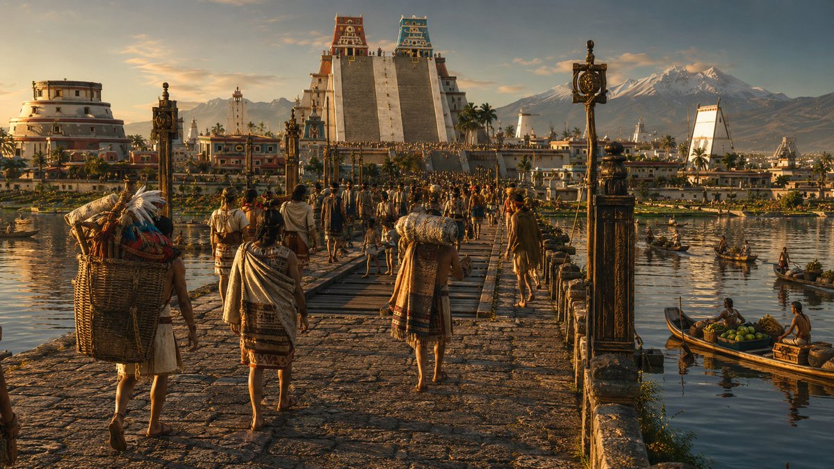
1519年,特诺奇蒂特兰的居民比伦敦更多。它是阿兹特克帝国的首都。它建在湖上,有运河和石头堤道横穿水面。它被称为“世界上最美丽的城市”…
分享链接 · https://openimages.ajiang.me/p/2071489354242179373/
camera_lens · deep-focuscolor_palette · warm-tonescomposition · high-anglecomposition · wide-shothuman_attributes · hands-prominentlighting · golden-hour
提示词(原文,逐字保留)
en 1519, Tenochtitlan tenía más habitantes que Londres.
era la capital del Imperio Azteca.
construida sobre un lago. con canales y calzadas de piedra que cruzaban el agua.
la llamaron "la ciudad más hermosa del mundo".
2 años después, los españoles la borraron del mapa.
le pedí a la IA que la reconstruyera.
¿qué ciudad antigua te gustaría ver reconstruida?
motor: gpt image 2
prompt 👇
{
"id": "tenochtitlan_1519_cinematica",
"titulo": "Tenochtitlan — México-Tenochtitlan, año 1519, Valle de Anáhuac",
"prompt": "Cinematic large-format anamorphic reconstruction — a single frame from an imaginary epic historical film, photographed on 65mm anamorphic film stock at 2.39:1 widescreen ratio. Emmanuel Lubezki cinematographic register: natural light only, no artificial sources, extreme tonal range, deep focus from foreground to horizon, the environment as protagonist. Late afternoon golden hour — the sun is descending in the WEST and slightly behind the viewer's position, casting long horizontal light that rakes across every surface from right to left, illuminating the full western and southern faces of the city's architecture and bathing the lake surface in a mirror of deep gold and amber. No lens flare — the light is controlled and painterly. The film grain is the fine structure of 65mm negative — present but subtle, adding texture to the sky and water without degrading architectural detail. VIEWPOINT: The camera is positioned on elevated ground on the western mainland shore — approximately from the wooded hill of Chapultepec, looking EAST-SOUTHEAST across Lake Texcoco toward the island city. The elevation is approximately 15-20 meters above the lake surface — high enough to see over the near shoreline reeds and show the full panorama, low enough to feel grounded in the physical world. The horizon line sits at approximately 40% from the bottom of the frame. FOREGROUND — THE WESTERN SHORE: In the extreme foreground, the rocky volcanic basalt shore of the mainland drops to the lake edge. Ancient ahuehuete trees (Taxodium mucronatum) frame the left and right edges of the frame — their massive gnarled trunks and draping feathery foliage dark against the lit sky, partially silhouetted. At the water's edge: reed beds (tule — Scirpus lacustris) dense and tall, their seed heads catching the golden sidelight and glowing amber. Three or four acalli canoes — flat-bottomed dugout canoes hewn from single logs — are beached or partially beached in the reeds, their dark wood surfaces catching highlights. Fishermen's nets are spread on the reed-flat to dry — fine mesh, wooden floats. A pair of white herons stand motionless in the shallows among the reeds, their feathers incandescent in the direct sidelight. Tracks of waterfowl visible in the mud at the water's edge. The ground cover: volcanic rock, coarse grass, wildflowers in yellow and orange. THE LAKE — LAKE TEXCOCO: The lake surface extends from the foreground shore to the island city and beyond. The water is shallow — at its maximum depth approximately 3 meters — and in the golden hour light it behaves as a mirror of extraordinary quality: the amber-gold of the sky, the white and colored forms of the island city, the distant blue-grey of the eastern mountains — all reflected with slight turbulence-distortion. The lake surface is NOT empty: dozens of acalli canoes of varying sizes cross in multiple directions — some laden with goods and provisions heading toward the city, their pilots standing and propelling with long poles or paddles. Some canoes carry stacked produce — maize, squash, flowers, pottery. Some are fishing canoes with nets deployed. Their wakes leave V-shaped ripples catching the light. Flocks of waterbirds — ducks, herons, ibis — rise and settle across the lake surface. THE IZTAPALAPA CAUSEWAY: Running from the southern mainland shore NORTHWARD toward the island, a massive raised stone causeway approximately 8 meters wide is visible in the middle distance, crossing the lake on a slight diagonal to the right of center. It is built of compacted earth and stone, elevated approximately 1 meter above the lake surface, with low stone parapets on both sides. The causeway surface is paved with flat volcanic stones, worn smooth by generations of use. Moving along the causeway in BOTH DIRECTIONS: a continuous stream of human figures — Mexica people in full 1519 dress. The figures heading toward the city: merchants carrying large loads in back-baskets (mecapal tumpline), women with clay vessels on their heads, noblemen in elaborate cotton and feather dress, warriors in quilted cotton armor (ichcahuipilli) with obsidian-edged wooden swords (macuahuitl). The figures are small at this distance but their movement and purpose is readable. At two points along the causeway: wooden drawbridges, currently lowered and in use — the mechanism of removable sections that can be pulled up visible as darker wooden structure crossing the stone. A second, smaller causeway is partially visible in the far background — the Tepeyac causeway heading north. THE ISLAND CITY — TENOCHTITLAN: The island rises from the lake approximately 1.5-2 meters above the water surface, its edges defined by the continuous line of chinampas — the famous floating gardens extending outward from the island's perimeter into the lake. The chinampas are densely planted rectangular garden plots separated by narrow water channels, vivid green with crops: maize, beans, squash, amaranth, flowers for the markets — the intense agricultural green contrasting with the gold of the lake water around them. The city itself is built in a precise grid of streets — which are actually canals — intersected by raised stone walkways. The flat rooftops of hundreds of single and two-story buildings extend across the island, white-plastered and gleaming in the western sun, their rooftop gardens and terraces visible, some with flowering trees. The density increases toward the center — the urban fabric packs tighter, the buildings slightly larger. ARCHITECTURE — THE SACRED PRECINCT (RECINTO SAGRADO): At the geometric center of the city, enclosed by the great serpent wall (coatepantli — a stone wall decorated with serpent relief carvings approximately 3 meters high), the sacred precinct contains the city's ceremonial heart. The TEMPLO MAYOR (Huey Teocalli) dominates the entire cityscape as an absolute vertical axis: a massive stepped pyramid approximately 60 meters tall, its square footprint approximately 80 meters per side, built in four receding stepped terraces of cut stone. The western face — facing the viewer — shows the twin staircases rising steeply to the summit in a single grand ascent. The stone of the pyramid body: cut tepetate and volcanic stone, plastered and painted. At the summit: two SHRINE CHAMBERS side by side. The SOUTH SHRINE (right) dedicated to Huitzilopochtli, the sun and war deity — painted in deep red and black, its frieze decorated with solar discs and warrior motifs, a stone eagle vessel (cuauhxicalli) at the top of the staircase. The NORTH SHRINE (left) dedicated to Tlaloc, the rain deity — painted in brilliant turquoise-blue and white, its frieze decorated with goggle-eyed masks and rain symbols. The two shrines glow in the late afternoon sun — the red-black and the turquoise-blue reading clearly against the darker sky. At the pyramid's base: the coatepantli's serpent heads — massive stone serpent heads project outward at the corners, painted in red, white and black. Immediately to the south of the Templo Mayor: the TZOMPANTLI skull rack — a long horizontal rack of wooden posts displaying hundreds of actual skulls in rows, the organic texture of bone contrasting with the cut stone of the plaza. The circular ROUND TEMPLE (dedicated to Ehecatl-Quetzalcóatl, the wind god) is visible to the southwest of the Templo Mayor — its unusual cylindrical form distinct among the rectangular structures, painted in white and black horizontal bands. The BALL COURT (Tlachtli) — a long I-shaped sunken court with high stone walls — is visible to the northwest of the Templo Mayor. Other smaller temple platforms and priestly structures fill the enclosure. BEYOND THE SACRED PRECINCT: Immediately to the south and east, the PALACE OF MOCTEZUMA II (Tecpan del Tlatoani) — an enormous low-rise complex of courts, halls, and gardens covering multiple city blocks, its scale indicated by its extent rather than its height. Flat roofs with garden plantings visible. The palace has colonnaded walkways and open patios, all in white plaster. To the north, across an internal canal: the adjacent island city of TLATELOLCO, its own Templo Mayor pyramid visible (slightly smaller than Tenochtitlan's) and beside it the great TIANGUIS (market) of Tlatelolco — the largest market in Mesoamerica, its extent visible as a large flat open area with rows of shade canopies and market stalls. DISTANT BACKGROUND — THE VALLEY AND MOUNTAINS: Beyond the eastern shore of the lake (behind the island city), the Valley of Mexico (Valle de Anáhuac) extends eastward — the lake's eastern shores lined with other lakeside cities: Texcoco directly east (the Aztec Triple Alliance's allied city, its own pyramid visible as a small triangular form on the eastern shore), Iztapalapa to the southeast (origin of the main causeway). The valley floor rises gradually to the mountain ranges. ON THE EASTERN HORIZON: The twin volcanoes of the Valley of Mexico rise in full magnificence — POPOCATÉPETL (5,452m) on the right, perfectly conical, its summit crater breathing a faint continuous plume of white volcanic smoke curling gently upward into the upper atmosphere — an active volcano in 1519 — the smoke plume lit amber-gold by the setting sun. IZTACCÍHUATL (5,286m) on the left, its profile the recumbent silhouette of the White Woman — the multiple summit ridges reading as the head, chest, knees and feet of a sleeping figure. Both summits are covered in permanent glacial snow and ice, the snow surfaces catching the warm western sidelight and glowing a deep amber-rose pink against the deepening blue-violet of the upper sky — the iridescent quality of glacial ice in golden hour. Between the volcanoes: the mountain pass of Paso de Cortés, a saddle of dark green pine forest. The mountain flanks descend through pine and oak forest to the valley floor. THE SKY: The sky at this golden hour is a gradient from deep gold-amber at the western horizon (behind the viewer) transitioning through pure gold and yellow-white to a deep cobalt blue at the zenith. High cirrus clouds in the upper right catch the last direct sun and glow platinum-white with amber edges. The sky is reflected in the lake surface in its full gradient — gold near, blue far. The atmospheric perspective of the valley is fully present: the near island city is crisp and detailed, the eastern shore cities are slightly softened, the volcanoes are further softened by 40 kilometers of atmosphere, their forms reading as soft sculptural masses. HUMAN SCALE THROUGHOUT: The city teems with visible human life at every scale — figures on the causeways, canoes on the lake, figures visible on the flat rooftops of the city, larger figures near the Templo Mayor plaza visible in the near distance. The scale of the human figures relative to the Templo Mayor's 60-meter height establishes the true monumentality of the structure. ANAMORPHIC OPTICAL QUALITIES: The 2.39:1 widescreen format and anamorphic lens characteristics are present — slight oval bokeh on out-of-focus highlights (the lake reflections, the waterfowl), a very subtle horizontal lens breathing, the specific depth and warmth of anamorphic glass. The image has the quality of a single decisive frame from a great historical epic — self-contained, compositionally resolved, historically specific.",
"negative_prompt": "any Spanish or European elements, any post-conquest elements, Christian churches or crosses, Spanish armor or weapons, horses (not present in pre-contact Mexico), modern buildings or infrastructure, power lines, contemporary vegetation inconsistent with 1519 valley ecology, incorrect architectural style (no European elements in buildings), digital color grading, flat even lighting, overcast sky without drama, empty lake without canoes, empty causeways without people, incorrect volcano profile, missing Templo Mayor twin shrines, missing color on temples (must be painted), Tenochtitlan looking like a generic medieval city, missing chinampas around island perimeter, missing lake reflections, clean grain-free digital image, missing atmospheric perspective",
"cinematographic_signature": {
"aspect_ratio": "2.39:1 anamorphic widescreen",
"film_stock": "Kodak Vision3 500T pushed one stop — 65mm negative",
"lens": "Panavision Sphero 65 anamorphic, 40mm equivalent — slight barrel distortion at edges",
"cinematographer_reference": "Emmanuel Lubezki ASC AMC — The Revenant (2015), Children of Men (2006)",
"light": "Practical golden hour only — no artificial sources, no fill, no reflectors",
"depth_of_field": "f/8 — full scene in acceptable focus from foreground reeds to distant volcanoes",
"grain": "65mm fine grain — present in sky and water, invisible in lit architectural surfaces"
},
"historical_accuracy": {
"city_population": "Approximately 200,000-300,000 — one of the largest cities on Earth in 1519",
"templo_mayor": "60 meters tall, twin shrines — Huitzilopochtli (red-black, south) and Tlaloc (blue-white, north), west-facing twin staircases",
"causeways": "Four main causeways: Iztapalapa (south, longest), Tlacopan (west), Tepeyac (north), Texcoco (east) — with removable wooden drawbridge sections",
"chinampas": "Artificial garden islands extending from the island perimeter — the agricultural foundation of the city",
"lake": "Lake Texcoco — shallow saline lake, maximum depth ~3m, surrounded by the interconnected lake system of the Valley of Mexico",
"volcanoes": "Popocatépetl actively smoking in 1519 — visible from the city at all times. Both Popo and Iztaccíhuatl snow-capped year-round",
"tlatelolco": "Adjacent twin city to the north of Tenochtitlan — its own Templo Mayor and the greatest market in Mesoamerica",
"year_context": "1519 — peak of Mexica power, Moctezuma II reigning, city at maximum development, months before first contact with Hernán Cortés"
},
"color_palette": {
"sky": "Deep cobalt blue at zenith → pure gold at western horizon",
"lake": "Mirror gold reflection of sky, disturbed by canoe wakes into liquid amber",
"city_buildings": "White plaster catching warm golden sidelight",
"templo_mayor": "Deep red-black (Huitzilopochtli shrine) + turquoise-blue-white (Tlaloc shrine)",
"volcanoes": "Deep blue-grey rock faces → amber-rose glacial snow in golden hour",
"chinampas": "Intense saturated green against the gold of the lake",
"ahuehuete_foreground": "Deep shadow green-black, backlit fringe of warm translucent foliage"
}
}
中文译文
1519年,特诺奇蒂特兰的居民比伦敦更多。它是阿兹特克帝国的首都。它建在湖上,有运河和石头堤道横穿水面。它被称为“世界上最美丽的城市”。两年后,西班牙人将它从地图上抹去。我让人工智能重建了它。你想看到哪座古城被重建?模型:gpt image 2 提示词 👇 { "id": "tenochtitlan_1519_cinematica", "标题": "特诺奇蒂特兰——墨西哥-特诺奇蒂特兰,1519年,阿纳瓦克谷", "提示词": "电影感大画幅变形宽银幕重建——一部虚构史诗历史电影中的单帧画面,使用65mm变形胶片拍摄,画幅比例为2.39:1宽屏。艾曼努尔·卢贝兹基摄影风格:仅使用自然光,无人工光源,极端色调范围,从前景到地平线都保持深景深,环境是主角。傍晚黄金时刻——太阳在西方落下,位置略在观者身后,投下长长的水平光线从右向左扫过所有表面,照亮城市建筑所有西向和南向立面,让湖面沐浴在深邃金色和琥珀色的镜面倒影中。无镜头眩光——光线可控且富有油画感。胶片颗粒是65mm底片的精细结构——存在但很柔和,为天空和水面增添纹理,不破坏建筑细节。视角:相机位于西部大陆岸边的高地上——大致从查普尔特佩克的林山出发,向东南偏东方向穿过特克斯科科湖眺望岛屿城市。海拔比湖面高约15-20米——高到足以越过近岸芦苇展现全景,低到足以让人感受到身处物理世界。地平线大约位于画面底部往上40%处。前景——西岸:在最前景,大陆的火山玄武岩岩岸降至湖边。古老的墨西哥落羽杉(Taxodium mucronatum)框住画面左右两侧——它们粗壮扭曲的树干和下垂的羽状 foliage 在明亮天空下呈深暗色,部分成剪影。水边:茂密高大的芦苇床(tule — Scirpus lacustris),它们的种穗接住金色侧光,泛出琥珀色光泽。三四艘acalli独木舟——由整根原木砍成的平底独木舟——搁浅或部分搁浅在芦苇中,深色木面捕捉到高光。渔夫的网摊在芦苇滩上晾干——细网眼,木质浮子。一对白鹭一动不动站在芦苇间的浅滩上,它们的羽毛在直射侧光下发出白炽光。水边泥地上可见水禽足迹。地被植物:火山岩、粗草、黄色和橙色的野花。湖泊——特克斯科科湖:湖面从前景岸边一直延伸到岛屿城市及更远。水很浅——最大深度约3米——在黄金时刻光线中,它像一面高质量镜子:天空的琥珀金色、岛屿城市的白色和彩色轮廓、东部山脉遥远的蓝灰色——都带着轻微湍流扭曲反射出来。湖面并非空无一物:几十艘大小不一的acalli独木舟从多个方向穿行——有些装载着货物和粮食驶向城市,船夫站着用长杆或桨推进。有些独木舟载着堆放的农产品——玉米、南瓜、花、陶器。有些是撒网的渔船。它们的航迹留下V形波纹捕捉光线。水鸟群——鸭、鹭、朱鹭——在湖面上飞起落下。伊斯塔帕拉帕堤道:从南部大陆岸边向北延伸至岛屿,一条宽约8米的巨型高架石堤在中景可见,略微斜向穿过湖泊,位于中心偏右。它由压实的泥土和石头建造,高出湖面约1米,两侧有低矮石护栏。堤道路面用平整火山石铺成,经过世代使用被磨损光滑。双向都有行人沿堤道移动:源源不断的人群——身着1519年完整服饰的墨西卡人。前往城市的人:商人用背篮(mecapal额带)背负大负载,女人头顶粘土容器,贵族穿着精致棉布羽毛服饰,战士穿着绗缝棉甲(ichcahuipilli),佩戴黑曜石边缘木剑(macuahuitl)。这些人物在这个距离下很小,但能看出他们的行动和目的。堤道上有两处:木质吊桥,目前降下使用——可拉起的可拆卸部分结构可见,是 crossing 石头的深色木质结构。远背景中隐约可见第二条较小堤道——向北延伸的特佩亚克堤道。岛屿城市——特诺奇蒂特兰:岛屿从湖中升起,高出水面约1.5-2米,边缘由连续的奇南帕(浮动菜园)线条界定——著名的浮动花园从岛屿 perimeter 向外延伸入湖中。奇南帕是密集种植的矩形菜园,被狭窄水道分隔,种着翠绿作物:玉米、豆类、南瓜、苋菜、供市场售卖的花——浓郁的农业绿色与周围湖泊的金色形成对比。城市本身按照精确的街道网格建造——街道实际上是运河,交叉着高架石步道。数百座一层和二层建筑的平顶遍布岛屿,涂着白灰,在西阳光下闪闪发光,屋顶花园和露台清晰可见,有些长着开花树木。向中心密度增加——城市结构更紧凑,建筑稍大。建筑——神圣区域(RECINTO SAGRADO):在城市几何中心,被巨蛇墙(coatepantli——约3米高、装饰蛇浮雕的石墙)环绕,神圣区域是城市的仪式心脏。大神庙(Huey Teocalli)作为绝对垂直轴主宰整个城市景观:一座约60米高的巨型阶梯金字塔,方形底座每边约80米,由切割石头建成四层退台式阶梯平台。朝观者的西立面可见双楼梯陡峭上升,一次宏伟登顶直达山顶。金字塔主体石材:切割的tepetate和火山岩,抹灰上色。山顶:并排两座神殿。南神殿(右侧)供奉太阳神和战神维齐洛波奇特利——涂成深红色和黑色,饰带装饰太阳盘和战士图案,楼梯顶端有石鹰容器(cuauhxicalli)。北神殿(左侧)供奉雨神特拉洛克——涂成明亮的青蓝色和白色,饰带装饰护目镜面具和雨符号。两座神殿在傍晚阳光下发光——红黑色和青蓝色在较暗天空下清晰可见。金字塔底部:coatepantli的蛇头——巨型石蛇头在角落向外突出,涂成红、白、黑色。大神庙正南方:TZOMPANTLI头骨架——长条形水平木柱架,一排排展示数百个头骨,骨头的有机纹理与广场的切割石头形成对比。圆形神庙(供奉风神埃赫卡特尔-克察尔科亚特尔)在大神庙西南方可见——其不寻常的圆柱形在矩形建筑中很突出,涂有黑白水平条纹。球场(Tlachtli)——一个长I形下沉球场,有高石墙——在大神庙西北方可见。其他较小的神庙平台和祭司建筑填满围地。神圣区域之外:紧邻南侧和东侧,是蒙特祖玛二世宫殿(Tecpan del Tlatoani)——一个巨大的低层建筑群,包含庭院、大厅和花园,占据多个街区,规模由其范围而非高度体现。可见带花园植物的平顶。宫殿有柱廊步道和开放庭院,全部用白灰粉刷。向北,穿过一条内部运河:相邻的特拉特洛尔科岛屿城市,可见它自己的大神庙金字塔(比特诺奇蒂特兰的稍小),旁边是特拉特洛尔科大集市(tianguis)——中美洲最大的集市,范围可见为一个大平坦开放区域,有一排排遮阳篷和摊位。远景——山谷和山脉:湖东岸(岛屿城市后方)之外,墨西哥谷(阿纳瓦克谷)向东延伸——湖东岸排列着其他湖滨城市:正东是特斯科科(阿兹特克三国同盟的盟城,它自己的金字塔在东岸可见为一个小三角形),东南是伊斯塔帕拉帕(主堤道的起点)。谷底逐渐上升至山脉。东地平线:墨西哥谷的双火山雄伟耸立——右侧是波波卡特佩特(5452米),完美锥形,火山口持续喷出微弱的白色火山烟柱,轻轻向上卷曲进入高层大气——1519年它是活火山——烟柱被落日染成琥珀金色。左侧是伊斯塔西瓦特尔(5286米),轮廓是“白衣女人”的卧姿剪影——多个山脊呈现出沉睡者的头、胸、膝盖和脚。两座山顶都覆盖永久冰川积雪,雪面捕捉到温暖的西侧光,在逐渐变深的 upper sky 蓝紫色背景下泛出深琥珀玫瑰粉色——黄金时刻冰川的虹彩质感。两座火山之间是科尔特斯山口,一片深绿松树林的鞍部。山坡通过松栎林向下延伸至谷底。天空:黄金时刻的天空是渐变,从西地平线(观者身后)的深金琥珀色,经过纯金色和黄白色,过渡到天顶的深钴蓝色。右上部分的高卷云接住最后直射阳光,泛出铂白色,边缘呈琥珀色。天空完整渐变反射在湖面——近处金色,远处蓝色。山谷的大气透视完全体现:近处岛屿城市清晰细节丰富,东岸城市稍柔和,火山被40公里大气进一步柔化,轮廓呈现柔和雕塑块面。全程保持人类尺度:城市各个尺度都充满可见的人类生活——堤道上的人物,湖上的独木舟,城市平顶屋顶上可见的人物,近景大神庙广场附近较大的人物可见。人类相对于60米高大神庙的尺度确立了建筑真正的宏伟。变形镜头光学特质:2.39:1宽屏格式和变形镜头特征都具备——失焦高光(湖面倒影、水鸟)有轻微椭圆形散景,非常细微的水平镜头呼吸,变形玻璃特有的深度和温暖。图像具有伟大历史史诗中一个决定性帧的质感——完整独立,构图完整,历史明确。" "负面提示词": "任何西班牙或欧洲元素,任何征服后元素,基督教堂或十字架,西班牙盔甲或武器,马(不 pres
来源与署名
原文由 @MiMundoConIA 发布在 X:查看原推文。 本页逐字保留原文并提供机器翻译的中文解读;版权归原作者所有。
同工具的更多提示词
- Gpt Image 2 | Nano banana 2 | Grok | Gemini Prompt 👇 以第一张图片作为主体面部与身份严格参考。准确保留男性…@AiWithTariq
- 酷热难耐的天气 ☀️,没有空调我能做什么呢 ❓ GPT- image 2 提示词 👇 一张自然的35毫米照片,画面中一位二十出头、容貌甜美的年轻日本女性,站在…@johnAGI168
- 1. 打开 Gemini / Grok / GPT Image 2.0 2. 上传你的照片 3. 复制提示词 4. 生成图片👇 "prompt_type"…@Fati_092
- https://t.co/yWGg5OBhvo 提示词: 超写实奢华洗发水宣传海报,1:1正方形画幅。一瓶线条流畅的品牌洗发水居中放置在大理石台面上,背景是柔…@iamaiistudio
- 👇 https://t.co/VG6gPeV4Sp@heyfionaai
- GPT Image 2 on ChatGPT ✨️ 提示词 ⬇ [参考图片] 使用参考照片,同时保持面部完全不变、与原始主体完全一致,超写实潮流服饰炒作杂志封…@ZephyraLeigh