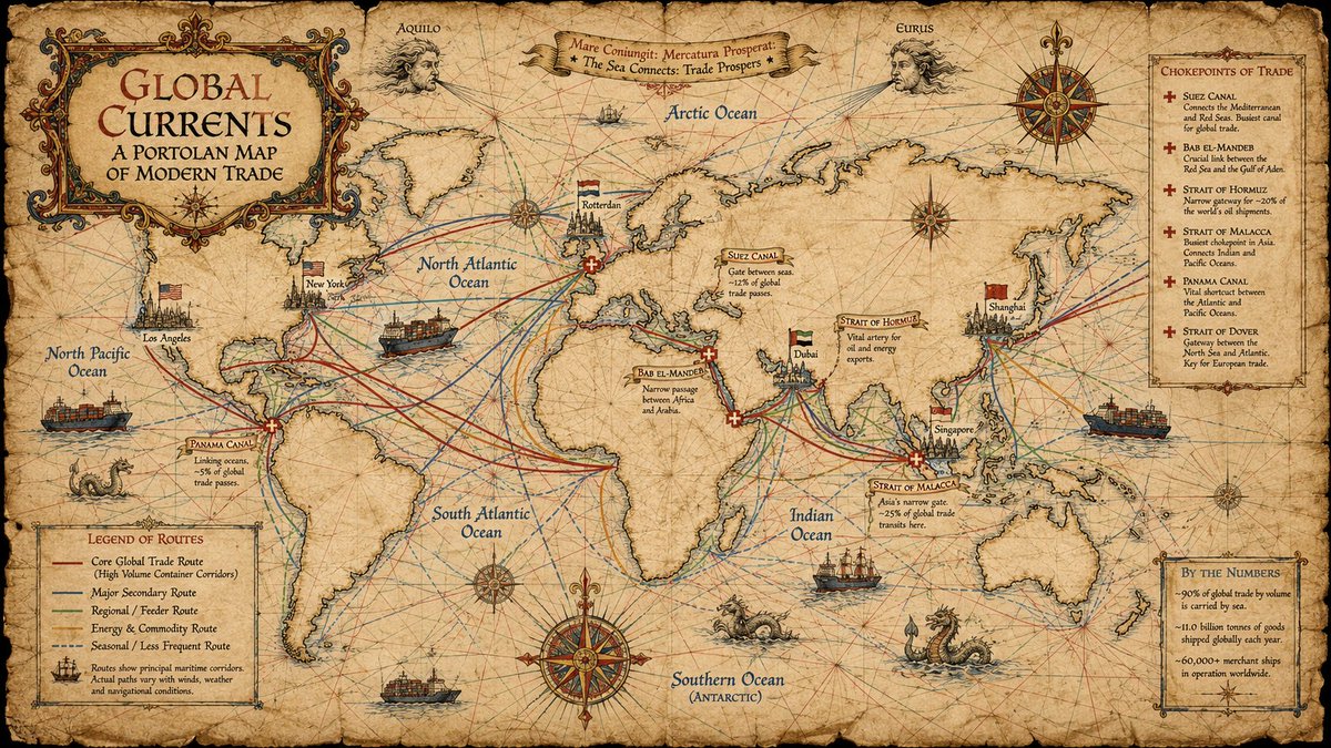
中世纪海港图(portolan chart)风格的信息图海报,16:9 横版,展示当今全球主要海上贸易航线,设计成仿佛一幅绘制在陈旧羊…
分享链接 · https://openimages.ajiang.me/p/2065314173706276977/
color_palette · earthycolor_palette · warm-tonescomposition · centeredcomposition · wide-shotlighting · natural-daylightmood · nostalgic
提示词(原文,逐字保留)
A medieval portolan chart style infographic poster in 16:9 horizontal format showing the main modern global maritime trade routes, designed to look like an authentic 14th‑century portolan map painted on aged vellum but annotated with 21st‑century data; the background should resemble yellowed sheepskin parchment with irregular edges, subtle creases and stains, and a warm sepia tone, with coastlines of all continents drawn as jagged ink outlines tightly hugging the oceans while the land interiors stay almost empty, just like historical portolan charts.[web:178][web:196][web:198] The seas are the star of the composition: criss‑crossed by a dense network of coloured rhumb lines radiating from elaborate compass roses, indicating cardinal directions and winds, and overlaid with bold, slightly curved trade routes that mark today’s core shipping corridors such as the trans‑Atlantic, trans‑Pacific, and the circum‑equatorial corridor linking North America, Europe and Pacific Asia through the Suez Canal, the Strait of Malacca and the Panama Canal.[web:178][web:195] Key maritime chokepoints such as Suez, Panama, Malacca, Bab el‑Mandeb, the Strait of Hormuz and the Strait of Dover are emphasized with small red icons, banners or marginal notes labelled CHOKEPOINTS OF TRADE, with short descriptive captions written in a narrow humanist script along the coasts.[web:195] Major container ports like Shanghai, Singapore, Rotterdam, Los Angeles and Dubai appear as tiny profile drawings of fortified harbour cities flying modern flags, echoing the way medieval charts depicted ports with stylized skylines and banners, while the oceans are populated with iconographic container ships and a few sea monsters for flavour. Include a decorative title cartouche reading GLOBAL CURRENTS – A PORTOLAN MAP OF MODERN TRADE in ornate hand‑lettered capitals, and a small legend box explaining line colours for core routes versus secondary routes.[web:195][web:196] Use a restrained palette of sepia, dark brown ink, muted reds and deep marine blue, with all modern information rendered through calligraphic labels rather than digital UI; the overall feel must be a believable hybrid of genuine medieval portolan aesthetics and contemporary trade geography, richly detailed yet readable, high quality, 16:9 horizontal ratio.
中文译文
中世纪海港图(portolan chart)风格的信息图海报,16:9 横版,展示当今全球主要海上贸易航线,设计成仿佛一幅绘制在陈旧羊皮纸上的真实14世纪海港图,但用21世纪的数据加以标注;背景应类似泛黄的羊皮卷羊皮纸,边缘不规则,带有细微的折痕与污渍,整体呈温暖的深褐色调,所有大陆的海岸线以锯齿状墨线勾勒,紧贴海洋,而陆地内部几乎留白,与历史上的海港图别无二致。[web:178][web:196][web:198] 海洋是构图的焦点:被密集的彩色罗经线(rhumb lines)网所交错,这些线从精美的罗盘玫瑰向外辐射,标示出方位与风向,并叠加在粗壮而微微弯曲的航线上,标出当代的核心航运走廊,例如跨大西洋、跨太平洋,以及连接北美、欧洲与亚太、途经苏伊士运河、马六甲海峡和巴拿马运河的环赤道走廊。[web:178][web:195] 苏伊士、巴拿马、马六甲、曼德海峡、霍尔木兹海峡与多佛尔海峡等关键海上咽喉要道,以小型红色图标、旗帜或页边注释突出标记,标注为"贸易咽喉"(CHOKEPOINTS OF TRADE),沿岸以狭窄的人文主义手写体写出简短的说明文字。[web:195] 上海、新加坡、鹿特丹、洛杉矶和迪拜等主要集装箱港口以微小的侧面图形式出现,描绘为飘扬现代旗帜的设防港口城市,呼应中世纪海港图以程式化天际线与旗帜表现港口的方式;海面上点缀着示意性的集装箱船与少量海怪,以增添趣味。包含一个装饰性的标题花框(cartouche),以华丽的手写大写字母书写"GLOBAL CURRENTS – A PORTOLAN MAP OF MODERN TRADE"(全球洋流——现代贸易海港图),并附一个小图例框,解释核心航线与次要航线所用的线条颜色。[web:195][web:196] 使用克制的色调:深褐、深棕墨、暗红与深海军蓝,所有现代信息均以书法式标签呈现,而非数字化界面;整体观感必须是真实中世纪海港美学与当代贸易地理之间令人信服的混合体,细节丰富却仍清晰可读,高质量,16:9 横版比例。
来源与署名
原文由 @92digitalartArt 发布在 X:查看原推文。 本页逐字保留原文并提供机器翻译的中文解读;版权归原作者所有。
同工具的更多提示词
- 低质量,模糊,多余四肢,多余手指,解剖结构扭曲,身体被裁切,手臂重复,腿部重复,比例失调,文字错误,水印,标志,签名,噪点,像素化,色彩过度饱和,平光照明,细…@HDWallArt
- 一位迷人的女士在乘坐地铁时低头看着她的智能手机,以随性的街头摄影风格拍摄。 #AIart #GPTImage2 https://t.co/EI5xE8oj3G@iamaiistudio
- https://t.co/AIsPIekhEW (注意:如果出现错误,请在GPT中按重新生成按钮 ︙) #AI #GPTImage #Prompt #AIar…@hongthich22470
- 使用 GPT Image 2 + Seedance 2.0 在 GPTProto 上创建。 1、GPT Image 2 上的提示词: "为一部名为《The P…@gptproto
- 一张专业、高分辨率的2026年国际足联世界杯数字体育海报。[PLAYER NAME] 端坐在《权力的游戏》中传奇的铁王座之上——一座由扭曲交织的刀剑组成、高耸…@Naiknelofar788
- https://t.co/5sUINWM3UE@Mind_Boticni