使用上传的图片作为路线规划地形图。红色线条仅表示预期的相机飞行路径和方向。红色线条及所有标注必须在最终视频中被完全移除。
分享链接 · https://openimages.ajiang.me/p/2062553617522106535/
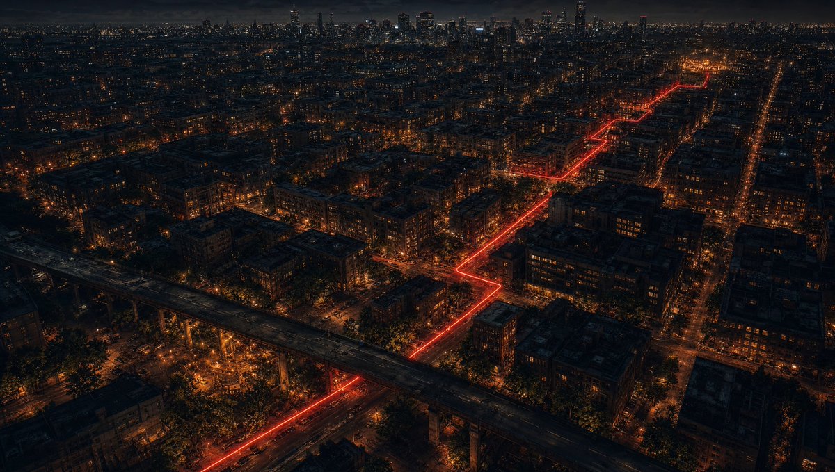
camera_lens · wide-anglecolor_palette · dark-moodycomposition · aerial-viewcomposition · dynamic-diagonallighting · low-keyscene · cityscape
提示词(原文,逐字保留)
Use the uploaded image as a route-planning terrain map. The red line indicates the intended camera flight path and direction only. The red line and all annotations must be completely removed from the final video.
Create a 15-second single continuous 16:9 cinematic FPV drone flight through the exact urban city world shown in the image. No cuts. No transitions. No teleporting. No map view. Invisible first-person drone camera only.
The camera must strictly follow the drawn red line route geometry from the upper-right starting point to the lower-left ending point — tracking two motorcycles riding through the city streets below throughout the entire flight.
TWO MOTORCYCLES VISIBLE THROUGHOUT:
SEI's cafe racer: matte black with honey gold stripe — the gold stripe catching each street lamp as they pass beneath it.
NEAR's street naked bike: matte dark grey and navy — darker and more understated beside SEI's.
Both riding side by side through the dark wet city streets below the drone — always visible on the route — always moving forward together. [ref: sei_motorcycle_sheet] [ref: near_motorcycle_sheet]
CRITICAL — THE RED LINE MUST NOT APPEAR IN THE VIDEO: The uploaded image is used ONLY as a route map reference for the camera path. The glowing red line visible in the reference image is a planning guide only — it must be COMPLETELY INVISIBLE in the final video. No red line. No glowing trail. No route marker. No path indicator of any kind visible on the streets. The streets must look like normal dark urban city streets — no red glow, no red light, no red trail on the road surface. The red line exists only to show the camera where to fly — it does not exist in the world of the video. Remove it completely.
TIMELINE:
0s–3s: Begin high above the city — the full dark urban world visible below. Dense city blocks. Streets with warm orange street lamp pools. The two motorcycles visible as tiny moving headlights on the streets below — tracking the route from the upper right. The city vast and dark. Drone moving forward smoothly following the route — staying high enough to see the full city scale. The two bike headlights the only things moving with purpose through the frame. CAMERA: High diagonal drone angle. Smooth forward motion. The full city visible below. Two tiny headlights tracking forward on the streets.
3s–6s: Drone beginning to descend while continuing forward — following the route as it turns through the city grid. The city details becoming sharper as altitude decreases. Street lamps creating rivers of orange light along the boulevards. The two bikes now slightly larger and more visible — SEI's gold stripe catching each street lamp they pass under. Buildings rising up around the frame as drone descends. The urban density visible — narrow alleys, graffiti walls, parked cars, wet asphalt reflecting the street lights below. CAMERA: Descending diagonal angle. The city detail sharpening. The two bikes growing larger and more visible.
6s–9s: Drone now at mid altitude — close enough to see both bikes clearly from above. SEI's cafe racer with gold stripe and NEAR's navy naked bike — side by side on the wet dark street. The drone directly behind and above them — following their exact path through the city. Street lamps passing in sequence below — the gold stripe catching each one. Wider boulevard visible ahead — the route straightening momentarily before turning. Buildings and graffiti walls close on both sides of the street below. CAMERA: Mid altitude directly behind and above both bikes. Both bikes clearly visible from above. Smooth forward motion matching their speed.
9s–12s: The route approaching the overpass structure — the massive elevated road visible ahead cutting through the urban grid. The drone following the bikes as they pass under or alongside the overpass. The concrete structure close — the drone passing near it. Under the overpass — brief darkness then emerging on the other side into the open urban space. The area around the overpass darker and more industrial. The two bikes pressing forward through this section. CAMERA: Close pass near the overpass structure — strong parallax and sense of speed. Brief darkness under the overpass. Emerging on the other side continuing forward.
12s–15s: Final approach — the drone now almost at street level directly behind both bikes. The city stretching ahead. The warm light cluster of THE CURRENT visible in the distance ahead — barely visible but there — the destination. The two bikes accelerating slightly toward it. The drone descending to nearly street level — directly behind them — the wet asphalt, the headlights, the dark street, the city around them all fully visible. The frame transitioning from drone above to street level behind as the scene ends. CAMERA: Final descent to near street level directly behind both bikes. The city around them. THE CURRENT warm light visible ahead in the distance. Strong forward momentum.
ENVIRONMENT: Dark urban city at night. Dense city blocks. Narrow streets and wide boulevards. Graffiti walls. Street lamps creating orange light rivers. Wet asphalt reflecting everything. Overpass concrete structure. Parked cars. Urban decay and overgrown vegetation. The city that exists between the cracks. Atmospheric night lighting. Strong sense of urban scale and depth.
CAMERA MOTION: Smooth cinematic FPV drone. Continuous uninterrupted forward flight following the red line route. Natural descent from high altitude to near street level throughout. Close pass near the overpass structure. Dynamic altitude changes matching the timeline. Strong foreground parallax from buildings and street furniture. Progressive descent toward street level. Smooth professional drone cinematography throughout.
VISUAL PROGRESSION: High above dark city → descending closer → both bikes clearly visible → overpass passage → near street level directly behind both bikes → destination visible ahead. The world getting closer and more immediate as the drone descends toward the two riders.
AVOID: Visible red line. Visible arrows. Annotations. Text. Subtitles. Logos. Watermarks. Map appearance. Teleportation. Jump cuts. Reverse movement. Visible drone. Camera rig. Any characters other than the two motorcycle riders. Modern sci-fi elements. Blurry terrain. Low detail. Flat environments. More than two motorcycles. More than two riders.
中文译文
使用上传的图片作为路线规划地形图。红色线条仅表示预期的相机飞行路径和方向。红色线条及所有标注必须在最终视频中被完全移除。
创建一段15秒的单镜头连续16:9电影级FPV无人机飞行,穿过图片中所示的精确城市世界。无剪辑。无转场。无瞬移。无地图视图。仅有不可见的第一人称无人机摄像机。
摄像机必须严格沿绘制的红色线条路线几何形状飞行,从右上起点到左下终点——在整个飞行过程中持续追踪下方穿过城市街道行驶的两辆摩托车。
整个过程中可见两辆摩托车:
SEI的cafe racer:哑光黑配蜂蜜金色条纹——金色条纹在他们驶过的每盏路灯下都会被照亮。
NEAR的street naked bike:哑光深灰与海军蓝——在SEI旁边更暗、更低调。
两辆车并排骑在无人机下方的黑暗潮湿城市街道上——始终在路线上可见——始终一起向前移动。[ref: sei_motorcycle_sheet] [ref: near_motorcycle_sheet]
关键——视频中不得出现红色线条:上传的图片仅用作摄像机路径的路线图参考。参考图中可见的红色发光线条仅为规划指引——在最终视频中必须完全不可见。没有红线。没有发光尾迹。没有路线标记。街道上没有任何形式的路径指示器。街道必须看起来像普通的黑暗城市街道——路面没有红色辉光、红色灯光或红色尾迹。红线仅用于指示摄像机飞行的位置——它不存在于视频世界中。将其完全移除。
时间线:
0秒–3秒:在城市高空开始——下方可见完整的黑暗都市世界。密集的城市街区。街道上有温暖的橙色路灯光池。两辆摩托车在下方街道上作为微小的移动车头灯可见——从右上追踪路线。城市广阔而黑暗。无人机沿路线平滑向前移动——保持足够高的高度以看到完整的城市规模。两辆摩托车的车头灯是画面中唯一有目的地移动的事物。摄像机:高角度对角线无人机视角。平滑向前运动。下方可见完整城市。两辆微小车头灯在街道上向前移动。
3秒–6秒:无人机在继续向前的过程中开始下降——沿路线穿过城市网格转弯。随着高度下降,城市细节变得更加清晰。路灯在林荫大道上形成橙色光河。两辆摩托车现在更大、更可见——SEI的金色条纹在他们经过的每盏路灯下被照亮。随着无人机下降,建筑物在画面周围升起。城市密度可见——狭窄的小巷、涂鸦墙壁、停放的车辆、湿沥青反射下方的街灯。摄像机:下降的对角线视角。城市细节变得清晰。两辆摩托车变得更大、更可见。
6秒–9秒:无人机现在处于中等高度——足够近从上方清楚看到两辆摩托车。SEI带金色条纹的cafe racer和NEAR的海军蓝naked bike——在潮湿的黑暗街道上并排。无人机直接在它们的上方和后方——跟随它们穿过城市的精确路径。路灯依次在下方经过——金色条纹每盏都被照亮。前方可见更宽的林荫大道——路线短暂变直后转弯。街道两侧的建筑物和涂鸦墙壁紧贴。摄像机:中等高度,直接在两辆摩托车的上方和后方。两辆摩托车从上方清晰可见。平滑的向前运动匹配它们的速度。
9秒–12秒:路线接近高架桥结构——前方可见穿过城市网格的巨大高架道路。无人机跟随摩托车从高架桥下方或旁边经过。混凝土结构很近——无人机从其附近经过。高架桥下——短暂的黑暗,然后在另一侧出现进入开阔的城市空间。高架桥周围区域更暗,更具工业感。两辆摩托车在这一段向前推进。摄像机:近距离经过高架桥结构——强烈的视差和速度感。高架桥下短暂的黑暗。在另一侧出现继续向前。
12秒–15秒:最终接近——无人机现在几乎在街道水平,直接在两辆摩托车后方。城市向前延伸。前方远处可见THE CURRENT的温暖灯光簇——勉强可见但在那里——即目的地。两辆摩托车略微加速向其前进。无人机下降到几乎街道水平——直接在它们后方——湿沥青、车头灯、黑暗街道、它们周围的城市全部完全可见。画面在场景结束时从无人机上方过渡到街道水平后方。摄像机:最终下降到接近街道水平,直接在两辆摩托车后方。它们周围的城市。THE CURRENT的温暖灯光在远处前方可见。强烈的向前动量。
环境:夜晚的黑暗城市。密集的城市街区。狭窄的街道和宽阔的林荫大道。涂鸦墙壁。路灯创造橙色光河。湿沥青反射一切。高架桥混凝土结构。停放的车辆。城市衰败和过度生长的植被。存在于裂缝之间的城市。大气夜间照明。强烈的城市规模和深度感。
摄像机运动:平滑的电影级FPV无人机。沿红色线条路线的连续不间断向前飞行。整个过程从高空自然下降到接近街道水平。近距离经过高架桥结构。匹配时间线的动态高度变化。来自建筑物和街道设施的强烈前景视差。逐步下降到街道水平。整个过程流畅的专业无人机摄影。
视觉进展:高空黑暗城市上方 → 下降靠近 → 两辆摩托车清晰可见 → 高架桥通道 → 接近街道水平直接在两辆摩托车后方 → 前方可见目的地。随着无人机向两名骑手下降,世界变得更近、更即时。
避免:可见的红色线条。可见箭头。标注。文本。字幕。标志。水印。地图外观。瞬移。跳剪。反向运动。可见无人机。摄像机支架。两辆摩托车骑手以外的任何角色。现代科幻元素。模糊的地形。低细节。平坦环境。两辆以上的摩托车。两名以上的骑手。
来源与署名
原文由 @dwlsdigital 发布在 X:查看原推文。 本页逐字保留原文并提供机器翻译的中文解读;版权归原作者所有。
同工具的更多提示词
- 超写实抓拍街头风格时尚照片,年轻女性以高角度远摄镜头俯拍,正在深色互锁砖块人行道上快步前行。明亮的自然阳光照亮步道的中央和右侧,左侧边缘被浓重的阴影覆盖。右侧…@elysra_ai
- 一幅超现实的电影感数字艺术作品,以上传的照片作为主要面部参考。尽可能贴切地保留此人的面部身份、面部结构、年龄、表情、发型、如有胡须则保留胡须、服饰风格以及可辨…@anythingmatrix
- { "composition": "以主体为主导的竖向构图,带有可触感的近景细节、受控的背景虚化和清晰的视觉层次", "negative_prompt": […@whoxswho
- 风暴天空,银色之缘,与马力。⚡ **Gemini 提示词** 物体与场景:纪录片风格的影院镜头:一位女性随意地将后背靠在银色超级跑车的侧面,处于混凝土跑道中央…@oye_samia
- 超写实电影感 RAW 照片,iPhone 17 Pro Max 拍摄,极致真实主义,奢华沙漠旅行美学,电影感生活方式摄影,真实自然的抓拍瞬间,细腻胶片颗粒,自…@AIwithYazdan
- 创作一张1:1方形的高端编辑级美食摄影图片,呈现以番茄罗勒意面为中心的经典意大利周六夜晚餐。 主菜必须是清晰的视觉主角:在一只暖色泥土色调、低边的哑光陶瓷盘上…@PrometheanAIX